
Index
Worldmap Providers
Specify a map tile provider to be used with the dashboard Worldmap panel:
- System-wide Default – in Dashboard Manger > Preferences
- Dashboard Specific – in the Worldmap tab of the map panel itself, requires Allow custom map providers = Yes (see Dashboard Manger > Preferences)
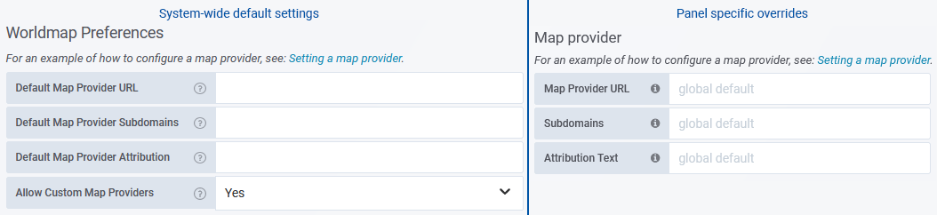
This provider is a 3rd party service providing a dynamic, scalable map resource. There are a range of commercial and open-source tile providers available offering a hosted/online service or providing the framework for deploying and hosting your own internal map tile server.
- Map Provider URL – specify the URL used to access your map tile service. The URLs for these services feature a number of notable parameters to identify the resource being displayed, these parameters are:
- {s} – (optional) a comma-separated list of subdomains, typically used by externally hosted services to spread the request load across multiple resources
- {x} – the X-coordinate of the map tile
- {y} – the Y-coordinate of the map tile
- {z} – the zoom level of the map
The order and location of these parameters within the URL may vary between providers. Refer to your map service provider’s documentation for the appropriate URL, or utilize one of the example configurations provided below.
Note: Statseeker requires that the {x}, {y} and {z} parameters are specified in lower-case.- If your provider documentation specifies the server URL as: https://maps-for-free.com/layer/relief/z{Z}/row{Y}/{Z}_{X}-{Y}.jpg
- Statseeker requires the URL to be specified as: https://maps-for-free.com/layer/relief/z{z}/row{y}/{z}_{x}-{y}.jpg
- Map Provider Subdomains – optionally, list the map provider subdomains to use. Each value in this string will be considered a valid subdomain for the {s} parameter in the Default Map Provider URL. This is a string of comma-separated values, no spaces. See your map service provider’s documentation for requirements.
Example: a,b,c or mapsub1,mapsub2,mapsub3
- Map Provider Attribution – enter any licensing attribution content required by your map service provider, see your map service provider’s documentation for requirements
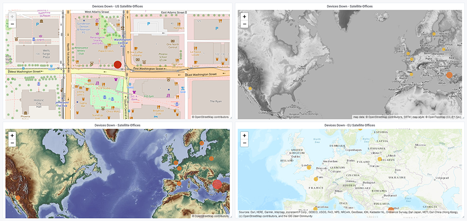
Example Service Provider URL Configurations
| Map | Map Provider URL | Map Provider Attribution | Subdomains | CartoDB | https://cartodb-basemaps-{s}.global.ssl.fastly.net/light_all/{z}/{x}/{y}.png | © CartoDB | a,b,c,d |
| CartoDB Positron – light theme | https://{s}.basemaps.cartocdn.com/rastertiles/light_all/{z}/{x}/{y}.png | © CartoDB | a,b,c,d |
| CartoDB Positron – dark theme | https://{s}.basemaps.cartocdn.com/rastertiles/dark_all/{z}/{x}/{y}.png | © CartoDB | a,b,c,d |
| OpenStreet:Default | http://{s}.tile.openstreetmap.org/{z}/{x}/{y}.png | © OpenStreetMap | a,b,c |
| ArcGIS:NatGeo | https://services.arcgisonline.com/ArcGIS/rest/services/NatGeo_World_Map/MapServer/tile/{z}/{y}/{x} | Sources: National Geographic, Esri, DeLorme, HERE, UNEP-WCMC, USGS, NASA, ESA, METI, NRCAN, GEBCO, NOAA, iPC | |
| maps-for-free | https://maps-for-free.com/layer/relief/z{z}/row{y}/{z}_{x}-{y}.jpg | © OpenStreetMap contributors | |
| Esri:Topo | https://services.arcgisonline.com/ArcGIS/rest/services/World_Topo_Map/MapServer/tile/{z}/{y}/{x}.jpg | Sources: Esri, HERE, Garmin, Intermap, increment P Corp., GEBCO, USGS, FAO, NPS, NRCAN, GeoBase, IGN, Kadaster NL, Ordnance Survey, Esri Japan, METI, Esri China (Hong Kong), (c) OpenStreetMap contributors, and the GIS User Community | |
| OpenTopo | https://{s}.tile.opentopomap.org/{z}/{x}/{y}.png | map data: © OpenStreetMap contributors, SRTM | map style: © OpenTopoMap (CC-BY-SA) | a,b,c |